


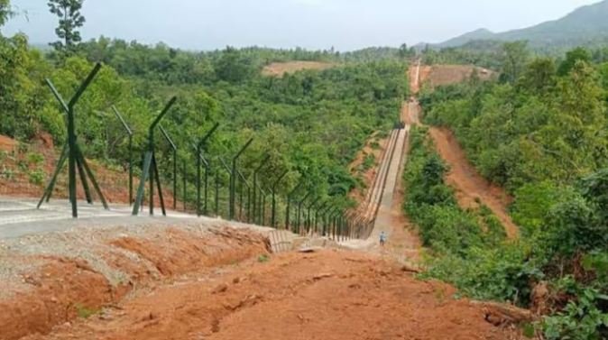
The question of land exchange between India and Myanmar in the Manipur sector cannot be reduced to survey language, boundary pillars, fencing alignments, or diplomatic file notes. It is a question that goes directly into the historical memory of Manipur, the security concerns of India, and the public trust that must govern every decision involving territory.
A recent report published in some independent media on July 17 claimed that the Government of India has sanctioned US$3.22 billion, approximately Rs. 27,000 crore, for fencing and constructing patrol tracks along the 1,643-km India-Myanmar border. The same report further alleged that an internal proposal under consideration involves resolving an undemarcated stretch between Border Pillars 65 and 68 in Chandel district through a territorial adjustment of about 3.6 sq km.
However, the Government of India has neither confirmed the existence of such a proposal nor announced any policy involving territorial exchange. This is precisely why official silence is no longer sufficient.
Since reports of a possible land exchange between India and Myanmar appeared in local and regional media, the silence of State legislatures has become deeply troubling. The Manipur Government under Yumnam Khemchand Singh has not issued any clear public statement, while the opposition parties have also failed to ask even a serious public question on an issue involving territory, border demarcation, security, and the historical memory of Manipur.
In a statement issued on July 27, the Coordinating Committee on Manipur Integrity (COCOMI) warned that it would not remain a silent spectator if the claims made in a report published by The Diplomat on July 17 were found to be true. Cautioning the Government of India against “playing with fire,” COCOMI said the report clearly identified the territory that Manipur could potentially lose, but failed to specify what land India would receive from Myanmar under the proposed exchange.
If the reports are incorrect, the Government must deny them; if discussions are taking place, it must explain their nature. The people have the right to know which portion of land is proposed to be given to Myanmar, which portion is expected to be received, and whether the exchange is meant to recover land earlier taken over by Myanmar or to surrender the land.
The matter becomes even more serious in the light of a Ministry of Home Affairs communication dated 26 May 2026. The letter records that during a meeting held on 11 May 2026 under the chairmanship of the Union Home Minister, the Foreign Secretary informed that a net area of 1.4 square miles is proposed to be exchanged with Myanmar in regard to the demarcation of Kabaw Valley.
The letter further states that fence works in the Kabaw Valley may be carried outside the no-construction zone of 10 metres from the India-Myanmar Border on the Indian side, based on the alignment of the 2017 boundary proposal of the Ministry of External Affairs. It also records that the Chair directed completion of demarcation within three months.
This raises the central question that every citizen of Manipur has the right to ask: which part of Manipur is proposed to be exchanged with Myanmar, and which part is India expected to receive from Myanmar?
The people must also be told whether this proposed land exchange is intended to take back land that historically or administratively belonged to Manipur but was taken over or occupied by Myanmar over past decades. If that is the case, the Government must clearly explain what land is being recovered, what land is being surrendered, what records support the claim, and whether Manipur gains or loses in the final settlement.
A territorial exchange cannot be explained merely by saying that 1.4 square miles or 3.6 sq km is involved. Such figures mean little unless the exact location is disclosed. Land is not an empty figure on a chart. It may include roads, habitations, forest areas, agricultural use, village boundaries, traditional routes, and areas of historical claim. For local communities, even a few hundred metres may carry inherited memory and livelihood significance.
The comparison between the 1980 proposal and the 2017 proposal for the Manipur sector of the India-Myanmar boundary shows that several pillars in the Molcham, Moreh, and Choro Khunou sectors were subject to revised positions, acceptance of existing ground locations, or introduction of auxiliary and subsidiary pillars.
Between Border Pillars 65 and 68, the 2017 proposal refers to several auxiliary pillars, including BP 65A, 65B, 65C, 66A, 66B, 67A, 67B, 67C, and 67D. This indicates that the area is not a simple straight-line demarcation. It involves adjustments, alignments, and ground realities that require careful public explanation.
The matter has also revived memories of the 2018 border pillar controversy, when residents of Kwatha Khunou in Tengnoupal district alleged that the proposed alignment of Border Pillar No. 81 would place nearly three kilometres of land claimed by villagers inside Myanmar. That controversy left behind a deep sense of suspicion. It also showed how quickly a technical border exercise can become a public issue when people believe that their land, memory, and identity are being decided without them.
Central government may have legitimate strategic reasons for completing border demarcation and fencing. The India-Myanmar border has become one of the most sensitive frontiers in the country. Insurgency, illegal migration, narcotics, arms movement, refugee flows, and instability inside Myanmar have placed great pressure on Manipur. Border fencing, patrol tracks, and formal demarcation may be necessary for national security. But national security cannot be built on public confusion.
If there is no territorial exchange proposal, the Government should say so. If there is such a proposal, the Government must disclose its broad contours without compromising sensitive diplomatic details. It must clarify whether Manipur is giving up land, regaining land, regularising ground possession, correcting old errors, or settling disputed claims through a mutual adjustment with Myanmar.
The people of Manipur cannot be expected to accept decisions involving their territory through leaked reports, partial documents, or administrative silence. The State Government must also not remain a passive observer. It has a constitutional and moral responsibility to seek complete details from the Centre and place the concerns of Manipur before the Union Government.
The officials concerned must come out with facts. They must identify the precise sectors involved. They must explain whether Border Pillars 65 to 68 fall under the reported adjustment. They must disclose whether any villages, customary lands, roads, or settlement areas will be affected. They must clarify whether any land claimed by Manipur is being recovered from Myanmar. They must also state whether any land presently under Indian administration will be transferred to Myanmar as part of the settlement.
Without such clarity, suspicion will grow. In Manipur, where territory has become deeply tied to identity, history, and political trust, silence can be more damaging than the decision itself.
The Kabaw Valley issue is not new. It carries a long memory in Manipur’s public consciousness. Whether all historical claims can be pursued under present international law is a separate question. But no government can ignore the emotional and historical weight of Kabaw Valley for the people of Manipur. Any decision related to this area must be handled with exceptional care.
The larger issue is not whether India should complete its international boundary work. It should. A modern state cannot leave its borders permanently ambiguous. Demarcation reduces conflict, strengthens security, and helps enforce law. But demarcation must not be carried out in a manner that creates new resentment among the very people who live along the border.
A boundary pillar may look like a technical marker to officials. To local people, it may decide belonging.
The India-Myanmar boundary must be secure. It must also be legitimate in the eyes of the people of Manipur. A fence may control movement, but only trust can secure a frontier.
The question of land exchange between India and Myanmar in the Manipur sector cannot be reduced to survey language, boundary pillars, fencing alignments, or diplomatic file notes. It is a question that goes directly into the historical memory of Manipur, the security concerns of India, and the public trust that must govern every decision involving territory.
A recent report published in some independent media on July 17 claimed that the Government of India has sanctioned US$3.22 billion, approximately Rs. 27,000 crore, for fencing and constructing patrol tracks along the 1,643-km India-Myanmar border. The same report further alleged that an internal proposal under consideration involves resolving an undemarcated stretch between Border Pillars 65 and 68 in Chandel district through a territorial adjustment of about 3.6 sq km.
However, the Government of India has neither confirmed the existence of such a proposal nor announced any policy involving territorial exchange. This is precisely why official silence is no longer sufficient.
Since reports of a possible land exchange between India and Myanmar appeared in local and regional media, the silence of State legislatures has become deeply troubling. The Manipur Government under Yumnam Khemchand Singh has not issued any clear public statement, while the opposition parties have also failed to ask even a serious public question on an issue involving territory, border demarcation, security, and the historical memory of Manipur.
If the reports are incorrect, the Government must deny them; if discussions are taking place, it must explain their nature. The people have the right to know which portion of land is proposed to be given to Myanmar, which portion is expected to be received, and whether the exchange is meant to recover land earlier taken over by Myanmar or to surrender the land.
The matter becomes even more serious in the light of a Ministry of Home Affairs communication dated 26 May 2026. The letter records that during a meeting held on 11 May 2026 under the chairmanship of the Union Home Minister, the Foreign Secretary informed that a net area of 1.4 square miles is proposed to be exchanged with Myanmar in regard to the demarcation of Kabaw Valley.
The letter further states that fence works in the Kabaw Valley may be carried outside the no-construction zone of 10 metres from the India-Myanmar Border on the Indian side, based on the alignment of the 2017 boundary proposal of the Ministry of External Affairs. It also records that the Chair directed completion of demarcation within three months.
This raises the central question that every citizen of Manipur has the right to ask: which part of Manipur is proposed to be exchanged with Myanmar, and which part is India expected to receive from Myanmar?
The people must also be told whether this proposed exchange is intended to take back land that historically or administratively belonged to Manipur but was taken over or occupied by Myanmar over past decades. If that is the case, the Government must clearly explain what land is being recovered, what land is being surrendered, what records support the claim, and whether Manipur gains or loses in the final settlement.
A territorial exchange cannot be explained merely by saying that 1.4 square miles or 3.6 sq km is involved. Such figures mean little unless the exact location is disclosed. Land is not an empty figure on a chart. It may include roads, habitations, forest areas, agricultural use, village boundaries, traditional routes, and areas of historical claim. For local communities, even a few hundred metres may carry inherited memory and livelihood significance.
The comparison between the 1980 proposal and the 2017 proposal for the Manipur sector of the India-Myanmar boundary shows that several pillars in the Molcham, Moreh, and Choro Khonou sectors were subject to revised positions, acceptance of existing ground locations, or introduction of auxiliary and subsidiary pillars.
Between Border Pillars 65 and 68, the 2017 proposal refers to several auxiliary pillars, including BP 65A, 65B, 65C, 66A, 66B, 67A, 67B, 67C, and 67D. This indicates that the area is not a simple straight-line demarcation. It involves adjustments, alignments, and ground realities that require careful public explanation.
The matter has also revived memories of the 2018 border pillar controversy, when residents of Kwatha Khunou in Tengnoupal district alleged that the proposed alignment of Border Pillar No. 81 would place nearly three kilometres of land claimed by villagers inside Myanmar. That controversy left behind a deep sense of suspicion. It also showed how quickly a technical border exercise can become a public issue when people believe that their land, memory, and identity are being decided without them.
Central government may have legitimate strategic reasons for completing border demarcation and fencing. The India-Myanmar border has become one of the most sensitive frontiers in the country. Insurgency, illegal migration, narcotics, arms movement, refugee flows, and instability inside Myanmar have placed great pressure on Manipur. Border fencing, patrol tracks, and formal demarcation may be necessary for national security. But national security cannot be built on public confusion.
If there is no territorial exchange proposal, the Government should say so. If there is such a proposal, the Government must disclose its broad contours without compromising sensitive diplomatic details. It must clarify whether Manipur is giving up land, regaining land, regularising ground possession, correcting old errors, or settling disputed claims through a mutual adjustment with Myanmar.
The people of Manipur cannot be expected to accept decisions involving their territory through leaked reports, partial documents, or administrative silence. The State Government must also not remain a passive observer. It has a constitutional and moral responsibility to seek complete details from the Centre and place the concerns of Manipur before the Union Government.
The officials concerned must come out with facts. They must identify the precise sectors involved. They must explain whether Border Pillars 65 to 68 fall under the reported adjustment. They must disclose whether any villages, customary lands, roads, or settlement areas will be affected. They must clarify whether any land claimed by Manipur is being recovered from Myanmar. They must also state whether any land presently under Indian administration will be transferred to Myanmar as part of the settlement.
Without such clarity, suspicion will grow. In Manipur, where territory has become deeply tied to identity, history, and political trust, silence can be more damaging than the decision itself.
The Kabaw Valley issue is not new. It carries a long memory in Manipur’s public consciousness. Whether all historical claims can be pursued under present international law is a separate question. But no government can ignore the emotional and historical weight of Kabaw Valley for the people of Manipur. Any decision related to this area must be handled with exceptional care.
The larger issue is not whether India should complete its international boundary work. It should. A modern state cannot leave its borders permanently ambiguous. Demarcation reduces conflict, strengthens security, and helps enforce law. But demarcation must not be carried out in a manner that creates new resentment among the very people who live along the border.
A boundary pillar may look like a technical marker to officials. To local people, it may decide belonging.
The India-Myanmar boundary must be secure. It must also be legitimate in the eyes of the people of Manipur. A fence may control movement, but only trust can secure a frontier.